The three vessels that will conduct the first round of seismic surveys for the Chevron-Helleniq Energy consortium in Greek waters will get under way the day after tomorrow, initially heading for waters southwest and south of the Peloponnese.
Geophysical surveys will take place in this area from Friday 20 November to 31 January 2027. The Greek-American consortium has asked the Coast Guard to issue a NAVTEX for the seismic survey vessel «Ramform Tethys» (Bahamas flag), the support vessel «Thor Freyja» (Faroe Islands) and the escort vessel «EDT Niovi» (Liberia).
The blocks where the US major is beginning its mapping are the adjoining “A2” (826 sq km) and “South of the Peloponnese” (11,000 sq km), which are much “easier” than those off Crete, not least because of the geopolitical factor.
That is also because the two blocks where the vessels will initially operate border another block, “Block 10” in the Kyparissia Gulf (2,376 sq km), where Chevron is also present. Detailed 3D seismic surveys have already been conducted there, and their analysis is under way.
In effect, the two blocks, “A2” and “South of the Peloponnese”, which the survey vessel «Ramform Tethys» will scan over the next two months, are a natural extension of “Block 10”. In other words, they form part of the same geological basin, meaning Chevron is likely to assess the data from all three blocks together. When the time comes to decide whether to drill or drop, any decision would cover prospects in all three of these offshore areas: Block 10, A2 and South of the Peloponnese.
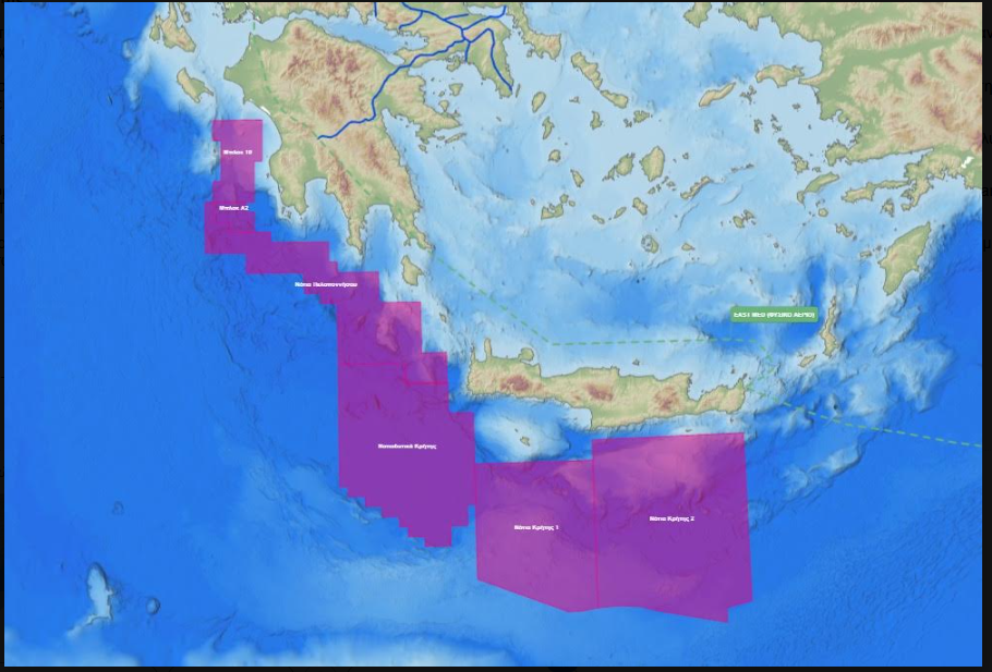
Together, the 2,376 sq km of “Block 10” and the two other blocks where Chevron is already the operator — “A2” (826 sq km) and “South of the Peloponnese” (10,211 sq km) — make up a single exploration area of more than 14,000 sq km. This gives it considerable flexibility in choosing drilling targets, statistically increasing the chances of finding commercially viable prospects.
Potential natural gas and oil structures
It also delivers economies of scale and reduces the costs of operations that run to many tens of thousands of dollars a day for a seismic vessel and its support ships.
“The proven petroleum system in the neighbouring licensed area of West Katakolo, together with the large number of surface oil and gas seeps in the wider area, make Block 10 a particularly interesting area.
Furthermore, several oil and gas fields have been discovered in Albania, which are part of the same fold-and-thrust belt and have the same geological characteristics,” the Hellenic Hydrocarbons and Energy Resources Management Company (HEREMA) says on its website about the Kyparissia Gulf block.
In other words, the two new blocks to be mapped, like the Kyparissia Gulf, could contain oil structures as well as gas — a possibility experts do not rule out.
Environment and Energy Minister Stavros Papastavrou had announced that Chevron would begin work before the end of the year. Yesterday, he had the opportunity to discuss broader developments surrounding the presence of oil majors in Greek waters with his US counterpart, Chris Wright, during their meeting at the seventh summit on transatlantic cooperation (P-TEC), which is taking place in Warsaw.
When work will begin south of Crete
The timing of the surveys, from late November to late January, is linked to the fact that seismic surveys are generally scheduled before the start of the tourist season (usually from autumn to early spring). In any case, they take place before Easter, after which shipping traffic increases.
The most decisive stage of Chevron’s programme, of course, concerns seismic surveys in the two blocks off Crete — “South of Crete 1” and “South of Crete 2”, covering a total area of 35,000 sq km — but no timetable for their start has been announced.
It is worth noting that the second of the two blocks extends to the median line with Libya and lies directly within the diagonal axis drawn by the Turkish-Libyan memorandum, which the parliament of eastern Libya ratified a month ago.
Asked when surveys might begin there, people following the issue do not rule out — depending also on the «Ramform Tethys»’s schedule — that they could take place by Easter, with a request for a second NAVTEX to be issued.
This would allow the US major to plan to complete seismic surveys across all five of its concessions in Greece in the first months of 2027, while also keeping costs down, since the survey vessel and its support ships will be in Greek waters anyway.